
Background
The software used here is adapted from NOVAS astronomical algorithms (www.usno.navy.mil). These are the subroutines used by the United States Naval Observatory in compiling the Astronomical Almanac.
References:
Kaplan, G. H., et al., AJ 97, 1197-1210, 1988
Kaplan, G. H., "NOVAS", Bull. AAS 22, 930-93, 1990
Kaplan, G. H., "The IAU Resolutions on Astronomical Reference Systems, Times Scales, and Earth Rotation Models", USNO Circular 179, 2005
Glossary of terms and definitions
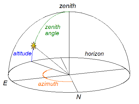
Altitude
The angle directly above (or below) the horizon. This is sometimes called "elevation". Altitude is the compliment of the zenith angle. That is, zenith angle plus altitude equals 90 degrees.
Astronomical twilight
Astronomical twilight begins in the morning, and ends in the evening, when the geometric center of the Sun is 18 degrees below the horizon. Outside these limits, the Sun does not contribute to sky illumination. See also nautical twilight and civil twilight.
Azimuth
The angle measured clockwise (eastward) from true north to the point on the horizon directly below (or above) the object. Historically, navigators have chosen north as the point of zero azimuth, while astronomers more frequently choose south. Here, we use north as our reference point. See also altitude.
Celestial equator
The projection of the Earth's equator onto the celestial sphere. This is the reference line declination (latitude) of the celestial coordinate system. The vernal equinox is taken as the reference point on the celestial equator. Right ascension is measured from this point eastward along the equator, counterclockwise as viewed from the northern celestial pole.
Celestial sphere
An imaginary sphere with essentially infinite radius, concentric with the Earth and fixed with respect to the distant stars, upon which any celestial object can be projected. The coordinate system normally superimposed on the celestial sphere consists of a projection of the Earth's equator and poles. Meridians of equal right ascension (longitude) connect the poles, and a point's declination (latitude) specifies the angle along a meridian from the celestial equator. The reference point of zero longitude on the celestial equator is the vernal equinox.
Civil twilight
Civil twilight begins in the morning, and ends in the evening, when the geometric center of the Sun is 6 degrees below the horizon. Within these limits, and with good weather conditions, terrestrial objects can be clearly distinguished, the horizon is clearly defined and the brightest stars are visible. Outside these limits, artificial illumination is normally required to carry on outdoor activities. See also astronomical twilight and nautical twilight.
Daylight Savings Time
The time convention in which local time is advanced one hour from Standard time, thereby adding an additional afternoon hour of daylight. Most regions in the United States observe DST from the second Sunday in Mach to the first Sunday in November. European nations begin DST on the last Sunday in March, and revert to Standard time on the last Sunday in October. In the southern hemisphere, the start and end dates are the reverse, with DST beginning in October or November and ending in March or April. Most of Asia and Africa remain on Standard time, and do not adopt DST.
Declination
One of two angles (the other being right ascension) in the equatorial coordinate system of the celestial sphere. The declination of a point on the celestial sphere is the angle measured along a meridian from the celestial equator to the point. Positive values indicate points north of the equator; negative values are given for points in the southern hemisphere. Right ascension and declination and are used as longitude and latitude respectively, to locate/specify the direction to celestial objects. See also right ascension.
Elevation
1) Altitude
2) The height of a point above the mean sea-level
Horizon
The line at which the ground and sky appear to meet. An observer's actual horizon varies with height and local topography. For astronomical calculations, the horizon is the set of points on the celestial sphere with zenith angle of 90 degrees.
Latitude
A point's geodetic latitude is the angle between the equatorial plane and the local vertical direction. The geocentric latitude of a point is the angle between the equatorial plane and the Earth-centered radius vector to the point. The maximum difference (less than 0.2 deg) occurs at about 45 degrees latitude, and there is zero difference at the equator and poles. In this application, we use latitude to mean geodetic latitude.
Longitude The longitude of a point on the Earth's surface is the angle, measured positively eastwards, between the Meridian of Greenwich the meridian containing the point. Longitude is often taken to be positive in the westward direction, so care should be taken to avoid this confusion. Here we use the positive-east convention, which is consistent with the IAU convention and also with a right-handed coordinate system with z in the north direction. It is, however, opposite the convention adopted by the IAU for every other planet!
Mean sea level
The surface defined by the geoid of gravitational equipotential that is used to approximate the Earth's surface.
Meridian
Half of a great-circle on the Earth's surface or celestial sphere connecting the north and south poles.
Nautical twilight
Nautical twilight begins in the morning, and ends in the evening, when the geometric center of the Sun is 12 degrees below the horizon. Within these limits, and with good weather conditions, general outlines of ground objects may be distinguishable, but detailed outdoor operations are not possible, and the horizon is indistinct. See also astronomical twilight and civil twilight.
Refraction
The change in direction of light upon entering a medium with a different index of refraction, at an angle other than normal to the interface. The atmosphere refracts light because the atmosphere's index of refraction changes with altitude. Refraction causes the rising or setting sun to appear higher than it otherwise would. Atmospheric refraction is most pronounced for rays coming from the horizon, and zero for rays coming from the zenith direction.
Right ascension One of two angles (the other being declination) in the equatorial coordinate system of the celestial sphere. The right ascension of a point on the celestial sphere is the angle measured eastward along the celestial equator from the vernal equinox to the meridian containing the point. Right ascension and declination and are used as longitude and latitude respectively, to locate/specify the direction to celestial objects. See also declination.
Sunrise, Sunset
Sunrise or sunset occurs when the top edge of the Sun appears to be on the unobstructed horizon. Refraction bends light from the horizon by about 0.5667 degrees in average atmospheric conditions, making the sun appear higher than it is. Because of this, and with average angular radius of the sun of 0.2667 degrees (it changes slightly over the year), we define sunrise and sunset as the times when the geometric center of the Sun is 0.8333 degrees beneath the horizon. Variations in local topography, observer elevation, atmospheric conditions, and other factors can cause time errors of a minute or more. Errors are more pronounced at very high latitudes. See also Civil twilight, Nautical twilight and Astronomical twilight.
Timezone
A geographic region using a common synchronized time system. Local times in neighboring timezones are generally one hour apart, although some differ by 15 or 30 minutes. Timezones are frequently specified by the difference between the local time in the timezone and Universal Time (Greenwich Mean Time). See www.jgiesen.de/astro/astroJS/timezone/index.htm for an interactive map.
True north
Direction on the horizon to the Earth's geographic north pole. The geographic pole is the rotation axis of the Earth, which differs considerably from the magnetic pole.
Vernal equinox
Also known as the "First Point of Aries", the vernal equinox is the point on the celestial sphere where the Sun's path (the ecliptic) ascends across the celestial equator. It is also used to denote the time of the Sun's passage over the celestial equator. This point is generally used as one of the reference points defining the coordinate system on the celestial sphere.
Zenith angle The angle between the local vertical and the direction to a point, as measured from the observer. For an observer on or near the Earth's surface, the local or geodetic vertical is assumed (normal to the Earth's ellipsoid), whereas for orbiting spacecraft, the geocentric vertical is used as the reference. Calculations here use the geodetic vertical as zenith angle. See also altitude.